Showing posts with label discovery. Show all posts

Sunday 23 July 2023

The Lost City of Petra: Explore the Historic Culture in the Heart of the Arabian Desert

Lost City Revealed: Unravelling the Mysteries of Petra

Petra's history dates back to around 312 BC when it was established by the Nabateans, a nomadic Arab tribe known for their advanced engineering and trade expertise. The city's strategic location along the ancient trade routes, particularly the Incense Route, allowed the Nabateans to flourish as a major commercial hub and amass great wealth from trade in frankincense, myrrh, spices, and other valuable goods.

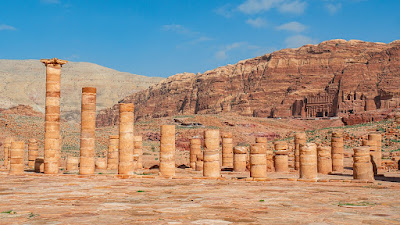
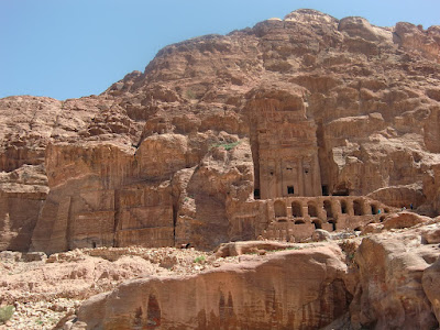
The most iconic feature of Petra is its unique rock-cut architecture. The city is nestled in a basin surrounded by towering sandstone cliffs, which made it an ideal place for the Nabateans to carve their monumental structures directly into the rose-red rock. The most famous building in Petra is the Treasury (Al-Khazneh), a magnificent façade carved into the cliff face that served as a tomb for a Nabatean king.

Lost City of Petra: A Desert Oasis of History and Wonder

Beyond the Treasury, Petra boasts numerous other impressive structures, including the Monastery (Ad Deir), the High Place of Sacrifice, the Great Temple, and the Royal Tombs, each displaying intricate carvings and stunning craftsmanship.

The Nabateans' ability to transform the rock into these monumental edifices showcases their exceptional architectural and engineering skills. The intricate channels and water conduits they constructed also highlight their mastery of water management, which was crucial for the city's survival in the arid desert environment.

Lost City of Petra: Treasures of the Ancient Arabian Desert

One of the key factors contributing to Petra's rise was its strategic location. The city was situated at the crossroads of several important ancient trade routes, most notably the Incense Route, also known as the Spice Route. This trade network connected southern Arabia to the Mediterranean world, passing through major centers such as Petra. As caravans laden with valuable goods, including spices, incense, silk, and precious metals, traversed these routes, Petra emerged as a vital commercial hub and a melting pot of diverse cultures.

Petra's prosperity was further enhanced by the Nabateans' exceptional engineering skills. Despite the challenging desert environment, they built an intricate water management system that allowed them to harness and control precious water resources. The city's water channels, cisterns, and dams enabled the Nabateans to store and distribute water efficiently, sustaining both the local population and the flourishing agricultural activities. This innovative water management system was essential for supporting the city's growth and transforming the rocky terrain into a habitable and thriving urban center.

As the Nabateans amassed wealth from trade and established their dominance in the region, they invested in the development of Petra, creating a city renowned for its grand architecture and unique rock-cut structures. Petra's most iconic landmark, the Treasury (Al-Khazneh), exemplifies the Nabateans' mastery of rock-cut architecture. Carved directly into the sandstone cliffs, the Treasury served as a royal tomb and a symbol of the city's opulence.

Lost City of Petra: Marvels of Rock-Cut Architecture

Beyond the Treasury, Petra boasted numerous impressive structures, including temples, palaces, tombs, theaters, and houses, all meticulously carved into the rose-red rock. These monumental edifices were adorned with intricate facades and beautiful carvings, showcasing the Nabateans' artistic talents and cultural influences from neighboring civilizations.

Despite its remarkable achievements, Petra's golden era began to wane in the 1st century AD as the dynamics of international trade shifted. The rise of maritime trade routes, particularly those facilitated by the Roman Empire, diverted commercial activities away from the desert caravans. Consequently, Petra's significance as a major trading center gradually declined.

In the 4th century AD, the city was largely abandoned, and over time, its existence faded from memory, eventually earning it the nickname "the Lost City." Petra remained hidden from the world until its rediscovery by Johann Ludwig Burckhardt in the early 19th century.

Lost City of Petra: Where History and Legend Converge

Since its rediscovery, Petra has captured the imagination of explorers, scholars, and travellers alike. Archaeological excavations and research have shed light on the city's history, unravelling its mysteries and showcasing the remarkable achievements of the Nabateans.

Petra's cultural and historical significance was officially recognized when it was designated as a UNESCO World Heritage Site in 1985. Today, it stands as one of the most iconic archaeological wonders in the world, drawing visitors from all corners of the globe who come to marvel at its breathtaking architecture, rich heritage, and awe-inspiring beauty.

Petra's history as a vibrant and prosperous city founded by the enterprising Nabateans, coupled with its remarkable architectural achievements and strategic importance as a trade hub, cements its place as one of the most captivating and significant archaeological sites in human history. The legacy of the "Lost City" lives on, continuing to inspire and captivate generations with its enduring allure and cultural richness.

Lost City of Petra: Resurrecting the Ancient Arab Civilization

Articles you might like:

Wednesday 7 June 2023

Uncovering the Buried Stone Heads at Easter Island

Unveiling Easter Island's Stone Heads: The Mystery of Buried Torsos

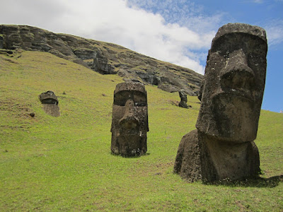
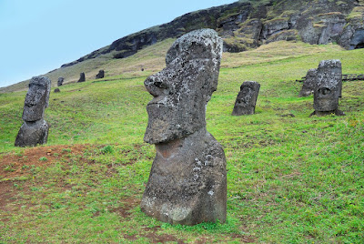
Easter Island, renowned for its iconic stone head statues known as moai, holds a hidden secret beneath the earth's surface. While archaeologists have documented 887 of these monumental sculptures, it is believed that there could be as many as 1,000 scattered across the island. Carved from volcanic rock between 1100 and 1680, the moai have fascinated researchers and visitors alike.

Revealing the Hidden Secrets: Stone Heads and Buried Bodies of Easter Island
Credit: Easter Island Statue Project

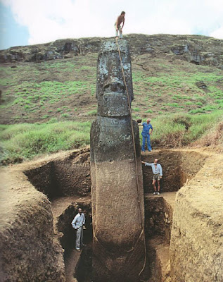
Unlike many other historic archaeological sites, the sheer size of the Easter Island statues has deterred theft. However, it was not widely known until recent years that the moai possess complete bodies concealed beneath the ground. While photographs of the statues undergoing excavation circulated in 2012, the bodies had actually been known to archaeologists since the early 20th century.

Approximately 150 statues are buried up to their shoulders on the slope of a volcano, making them the most famous and visually striking of all the Easter Island statues. Prior to the release of excavation photos, these buried torsos were often mistaken for head-only statues. The discovery of complete bodies brought widespread attention to the Easter Island Statue Project, with their website crashing due to a surge of interest and millions of online hits.

Easter Island's Stone Heads: Unearthing the Enigma of their Buried Torsos
Credit: Easter Island Statue Project

Leading the project, director Jo Anne Van Tilburg and her team conducted meticulous excavations in 2010, providing the first comprehensive scientific documentation of the moai. This ground-breaking work shed light on the importance of delving beneath the surface to unravel the mysteries surrounding these ancient sculptures. Tilburg's excavations captured the imagination of people worldwide, fueling a renewed fascination with Easter Island and its enigmatic stone heads.

From Heads to Torsos: The Intrigue of Easter Island's Stone Sculptures
Credit: Easter Island Statue Project

As visitors continue to explore Easter Island, the hidden torsos of the moai serve as a reminder of the island's rich history and the enduring allure of its ancient past. The ongoing research and discoveries surrounding these remarkable statues offer valuable insights into the island's cultural heritage, leaving us in awe of the artistic achievements of the ancient Rapa Nui civilization.

The Hidden Half: Exploring the Buried Bodies of Easter Island's Stone Heads
Credit: Easter Island Statue Project

With the newfound understanding of the Easter Island statues, the story of this remote island in the Pacific Ocean becomes even more captivating. The buried torsos add depth to the narrative, inviting us to contemplate the remarkable craftsmanship and cultural significance of these monumental sculptures. As researchers continue their investigations, the secrets of Easter Island's stone head statues are gradually unveiled, providing a fascinating glimpse into a bygone era.

Unlocking Easter Island's Enigma: The Truth Behind the Stone Heads and Buried Torsos

History of Easter Island

Easter Island, also known as Rapa Nui, is a remote Polynesian island located in the south-eastern Pacific Ocean. The island is renowned for its iconic stone head statues, called moai, which have fascinated the world for centuries. While Easter Island is famous for these enigmatic sculptures, it also boasts a rich and intriguing history.

The earliest settlers of Easter Island are believed to have arrived around 1200 CE, originating from other Polynesian islands. These early inhabitants developed a unique culture and society over the centuries. The moai statues, carved from volcanic rock, emerged as a prominent feature of their civilization.

The Fascinating Tale of Easter Island's Stone Sculptures

The construction of the moai began around the 13th century and continued until the late 17th century. These colossal statues, ranging in height from a few meters to over 20 meters, were created to honor ancestral chiefs and other important figures. The precise techniques used to carve and transport these massive stone figures remain a subject of debate and speculation.

By the time European explorers arrived in the 18th century, Easter Island had undergone significant changes. The island's resources, including its lush forests, had been depleted, leading to ecological decline and social unrest. Conflicts and competition over limited resources had a profound impact on the island's population.

One of the enduring mysteries surrounding Easter Island is the collapse of its civilization. By the time Europeans encountered the island, its society had undergone a significant decline. The exact reasons for this collapse are still debated among researchers, but factors such as deforestation, overpopulation, social unrest, and resource depletion likely played a role.

Uncovering the Buried Torsos of Easter Island's Stone Heads

European contact with Easter Island had a profound impact on its native population. The island was visited by various explorers and traders, and later came under the control of different colonial powers, including the Spanish and the Dutch. These encounters brought diseases, forced labor, and cultural disruptions to the island's inhabitants.

In the 19th and early 20th centuries, Easter Island saw further waves of colonization and changes in governance. In 1888, Chile annexed the island, and it remains an overseas territory of Chile to this day. Efforts to preserve and study the island's cultural heritage have been ongoing, with archaeological research shedding light on the island's fascinating past.

Today, Easter Island is recognized as a UNESCO World Heritage site, attracting visitors from around the world who come to witness the awe-inspiring moai statues and explore the island's captivating history. Efforts are being made to preserve the island's natural environment and cultural heritage, ensuring that future generations can continue to marvel at the remarkable legacy of Easter Island's ancient civilization.

Articles you might likes:

Sunday 28 May 2023

Possible Underwater City Found in America that's 12,000 Years-Old

In Search of Atlantis: George Gelé's Controversial Discovery off the Louisiana Coast

Beneath the waters near the uninhabited Chandeleur Islands, located 50 miles east of New Orleans, a retired architect named George Gelé claims to have discovered the remains of a submerged city that dates back 12,000 years. This amateur archaeologist believes that the mysterious granite stones found by local fishermen are actually architectural artifacts from an ancient lost civilization predating the well-known Inca, Maya, and Aztec civilizations of the Americas. Gelé's most astounding assertion is the presence of a pyramid, named "Crescentis," within the granite city, which he believes shares a geographical connection to the Great Pyramid of Giza. While Gelé's claims have been met with skepticism, they have sparked curiosity and debate among experts and locals alike.

Unexplained Granite Stones and Underwater Ruins:

The foundation of Gelé's theory rests on the discovery of strange square rocks made by local fishermen near the Chandeleur Islands. The presence of granite in the area is perplexing since it is not naturally found in Louisiana or Mississippi. Gelé, who has made 44 trips to the site over nearly 50 years, has produced underwater sonar images that he believes reveal discernible ruins of major buildings, including a large pyramid. These findings, covered in sand and silt, fuel Gelé's conviction that an ancient city lies submerged off the coast.

From Granite Stones to Submerged Ruins: The Intriguing Tale of Chandeleur's Underwater City
Where did the granite come from? Credit: WWLTV


The Electromagnetic Enigma:

Gelé's claims gain further support from eyewitness accounts, such as that of local shrimper Ricky Robin. Robin recalls his boat's compass spinning uncontrollably near the alleged pyramid's location, suggesting an intense electromagnetic energy emanating from the structure. According to Robin, all electronics on his boat malfunctioned in a manner reminiscent of the Bermuda Triangle phenomenon. These intriguing anecdotes add an element of mystery to Gelé's theory and have fuelled speculation about the origin and purpose of the granite structures.

Beyond Myth and Legend: Investigating the Possibility of an Ancient Underwater City
Are these ruins natural or ma-made? Credit: WWLTV


Alternative Explanations:

While Gelé's theory captures the imagination, many experts remain skeptical and propose alternative explanations for the granite stones and underwater ruins. A late 1980s Texas A&M study suggests that the granite blocks may have originated from old shipwrecks or served as ballast stones discarded by Spanish and French ships to lighten their load when entering shallow waters. Gelé himself presented similar possibilities in 2014, exploring the idea that the stone piles could be remnants of construction projects or the result of several shipwrecks. LSU archaeology professor Rob Mann suggests that the granite slabs might have been placed there in the 1940s during an attempt to create an artificial coral reef.

The Quest for Scientific Validation:

While Gelé's theory remains unproven, it has garnered attention and curiosity among researchers. However, to obtain serious scientific backing, Gelé's claims require further exploration. Future dives, advanced sonar technology, and satellite imaging could potentially provide the evidence needed to validate or refute his hypothesis. With over 80% of the ocean still unexplored, recent discoveries of ancient ruins and artefacts by underwater archaeologists demonstrate the potential for more extraordinary findings in the future.

Exploring the Uncharted: The Lost City Hypothesis and George Gelé's Intriguing Findings

George Gelé's assertion of a 12,000-year-old underwater city off the coast of Louisiana has generated excitement and skepticism in equal measure. While Gelé presents intriguing evidence, including the presence of granite stones and underwater sonar images of discernible ruins, alternative explanations propose more conventional origins for these artifacts. The quest for scientific validation continues, and as advancements in technology open up new possibilities for exploration, the mystery surrounding the alleged submerged city near the Chandeleur Islands remains unsolved. As we venture further into the unexplored depths of our oceans, there is always the promise of uncovering ancient civilizations and remarkable artifacts. The underwater world holds countless secrets that have yet to be revealed. Gelé's theory serves as a reminder that our understanding of history is constantly evolving, and there may be undiscovered chapters waiting to be explored.

While Gelé's claims may seem fantastical, it is essential to approach them with a critical lens. Skepticism is a vital part of the scientific process, ensuring that extraordinary claims are subjected to rigorous scrutiny. As experts continue to investigate the origins of the granite stones and underwater ruins, it is crucial to consider alternative explanations proposed by previous studies.

Nevertheless, Gelé's determination and passion for his findings should not be dismissed outright. His relentless pursuit of uncovering a lost civilization serves as a testament to the enduring human curiosity about our past. The allure of an ancient underwater city, complete with a pyramid emitting mysterious energy, captures our imagination and fuels the desire to explore uncharted territories.

The future of underwater exploration holds great promise. Advancements in sonar technology, satellite imaging, and deep-sea diving capabilities provide researchers with unprecedented tools to investigate and document submerged archaeological sites. These advancements may one day provide the conclusive evidence needed to support or debunk Gelé's claims.

Whether Gelé's hypothesis proves to be an accurate interpretation or an elaborate misconception, the pursuit of knowledge and the exploration of our planet's mysteries remain at the forefront of scientific endeavors. The story of the alleged underwater city near the Chandeleur Islands is a reminder that our world continues to hold secrets waiting to be unearthed, and only through dedicated research, open-mindedness, and the relentless pursuit of truth can we hope to unlock the secrets of our past.

Articles you might like:

Wednesday 24 May 2023

Recently Discovered Mayan Civilization Found Hidden in Jungle

Lost Cities Unveiled: Rediscovering the Magnificence of the Ancient Mayan Civilization
Image Credit: Al Argueta / Alamy Stock Photo / Wikimedia

Deep within the impenetrable jungles of Guatemala, a remarkable discovery is sending shockwaves through the archaeological community. In a landscape shrouded in mystery and centuries of overgrowth, an extensive network of Mayan cities has been unveiled, compelling experts to rewrite the pages of history. This astounding revelation unveils a tapestry of over 400 new settlements, each whispering secrets of a civilization long forgotten. The narrative of the Mayans, once thought to be that of wandering hunter-gatherers, is now transformed into a tale of thriving urban centers intricately connected through a ground-breaking system of roads—an ancient precursor to the modern freeway system. This unparalleled find has been hailed as a "game-changer," defying previous notions and transporting us to an era of extraordinary complexity and architectural grandeur. As we stand on the threshold of these resplendent Mayan cities, we are beckoned to embark on a transformative journey that promises to unravel a lost volume of human history and reshape our perception of one of the world's most enigmatic civilizations. Prepare to immerse yourself in the lush wonders of the El Mirador jungle as we venture forth into the heart of ancient Mayan civilization, where every crumbling stone and intricate artefact reveals a profound tale of ingenuity, heritage, and the enduring spirit of human endeavour.

Unearthing a Hidden Legacy:

The archaeological expedition in the El Mirador jungle has revealed a treasure trove of Mayan cities dating back to 1,000 BC. Previously believed to be nomadic hunter-gatherers, the Mayans, it turns out, were masters of urban planning and construction during the Preclassic period. Renowned archaeologist Richard Hansen described the discovery as a game-changer, highlighting the complexity and architectural sophistication of this ancient civilization.

The Mayan Enigma Revealed: Discovering a Vast Network of Lost Cities in Guatemala
Image Credit: Idaho State University/Richard Hansen

A Journey through Dense Wilderness:

Reaching the newly discovered sites was no easy feat. The El Mirador jungle, with its dense vegetation, presented a formidable challenge. The archaeological team had to navigate through treacherous terrain, confronting potential dangers from jaguars and snakes that roamed the area. The expeditions involved arduous 40-mile hikes or helicopter transport. These intrepid researchers defied the odds to unveil the hidden marvels concealed within the rainforest.

Unlocking the Secrets with Lidar Technology:

The ground-breaking research began in 2015, employing cutting-edge lidar technology to penetrate the dense foliage without causing harm to the environment. Lidar scans provided a unique perspective, generating 3D images of the ancient structures and revealing the foundations of the Mayan settlements. These advanced radar techniques allowed archaeologists to explore the hidden remnants of a civilization lost to time.

From the Depths of the Jungle: Exploring the Newly Discovered Mayan Metropolises

Discoveries That Transcend Expectations:

The findings surpassed all expectations, uncovering not only 417 new cities but also an astonishing 110 miles of interconnected "superhighways." Much like modern urban centers, the Mayan sites exhibited evidence of sophisticated hydraulic systems and agricultural infrastructure. The discoveries have provided a glimpse into a thriving civilization that flourished in the heart of the jungle for thousands of years.

Expanding the Known Boundaries:

The lidar technology not only confirmed existing settlements but also unveiled an additional 900 sites that were previously invisible to the naked eye. The application of this innovative technique has expanded our understanding of the extent and scale of the Mayan civilization. Archaeologist Enrique Hernández expressed his excitement about the discoveries, emphasizing the previously unimaginable scope of Mayan settlements that now come to light.

A Testament to Human Ingenuity:

The recent Mayan excavation has revealed a chapter of human history previously unknown. It attests to the incredible ingenuity, architectural mastery, and societal complexity of the ancient Mayan civilization. These findings provide valuable insights into the cultural, technological, and agricultural advancements of the Mayans, inviting us to reassess our understanding of this remarkable civilization.

The Mayan Empire Resurrected: Unveiling the Hidden Cities of Guatemala's Rainforests

The discovery of a vast network of Mayan cities in the Guatemalan jungle has rewritten the narrative of Mayan civilization. The unveiling of over 400 settlements, interconnected by roads, highlights the architectural sophistication and urban planning capabilities of the Mayans. Thanks to lidar technology, archaeologists have gained access to a hidden world, unlocking the secrets of an ancient civilization that thrived in the heart of the rainforest. This remarkable discovery stands as a testament to the enduring legacy and cultural significance of the Mayan civilization, leaving us in awe of their remarkable achievements.

Articles you might like:
Monday 22 May 2023

The Piri Reis Map: Antarctica's Mysterious Prehistoric Past Revealed

Antarctica's Ancient Enigma: Unravelling the Secrets of the Piri Reis Map

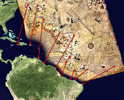
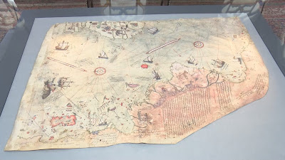
The enigmatic Piri Reis Map has been a source of fascination and debate for scholars, historians, and cartographers alike. Its discovery in 1929 by Gustav Deissmann sparked a journey into the unknown, unveiling a world that defied conventional understanding. As we delve deeper into its intricacies and implications, the map opens doors to a multitude of possibilities, shattering the boundaries of our knowledge and challenging the narratives of our history.

The presence of Antarctica on the Piri Reis Map, a landmass that was not officially discovered until 300 years later, raises profound questions about the origins of this knowledge. How could Piri Reis, drawing on sources from ancient civilizations such as the Greeks and Portuguese, have depicted Antarctica without its icy covering? Was there a lost civilization, existing thousands of years ago, that possessed advanced navigational skills and the ability to chart the globe with remarkable accuracy? The inclusion of Antarctica before its transformation into an icy wilderness hints at the existence of an ancient world far more technologically advanced than previously imagined.

Mapping Antarctica: The Piri Reis Enigma and Lost Civilizations

Moreover, the utilization of the Mercator Projection, a mapping technique not introduced until the late 16th century, adds an additional layer of mystery to the Piri Reis Map. How could Piri Reis have employed a methodology that was ahead of his time? Did he have access to knowledge and resources that have since been lost to history? Or does this point to the influence of extraterrestrial beings who imparted their advanced understanding of cartography to ancient civilizations? The enigmatic origins of the Mercator Projection on the map continue to bewilder researchers, leaving ample room for speculation and intrigue.

While skeptics argue that the landmass depicted on the Piri Reis Map is simply an accurate representation of the South American coastline, the existence of other maps resembling an ice-free Antarctica raises questions about this interpretation. Could it be that Piri Reis was indeed depicting Antarctica, and that our understanding of its history and formation is incomplete? The possibility of a prehistoric civilization that had a profound understanding of the Earth's geography, possessing not only navigational and cartographic skills but also aerial capabilities, leads to tantalizing conjectures. Some even connect these theories to the legendary lost city of Atlantis, envisioning a technologically advanced society that thrived in the depths of antiquity.

Charles Hapgood, with his book "Maps of the Ancient Sea Kings," presented compelling theories about the Piri Reis Map and its implications. His notion of a prehistoric civilization predating 4000 BCE, capable of circumnavigating the globe and accurately charting its lands, challenges conventional timelines and calls into question the trajectory of human development. Although some of Hapgood's hypotheses have been dismissed, his work ignites the imagination and encourages us to explore alternative possibilities in our quest to understand the secrets hidden within the ancient world.

Lost World of Antarctica: Decoding the Piri Reis Map's Clues

As we stand at the crossroads of knowledge and uncertainty, the Piri Reis Map reminds us of the boundless mysteries that lie in wait. It beckons us to cast off the shackles of conventional thinking and embrace the idea that our past may hold wonders and truths beyond our current comprehension. While the true nature and origin of the map remain elusive, its existence alone stirs our curiosity and sparks a thirst for discovery.

The journey to decipher the secrets of the Piri Reis Map is far from over. The pursuit of definitive evidence and a comprehensive understanding continues, as researchers, historians, and enthusiasts delve into the depths of antiquity. With each revelation and each unanswered question, the map invites us to revaluate our perceptions of history, to reconsider the capabilities of ancient civilizations, and to embrace the awe-inspiring notion that our world may have been shaped by forces far more extraordinary than we ever imagined.

In the end, the significance of the Piri Reis Map extends far beyond its enigmatic features. It challenges us to question the limits of human achievement and the depth of our understanding of the past. The map serves as a potent symbol of our ceaseless pursuit of knowledge and the unending quest to unravel the mysteries of our world.

As technology advances and new discoveries emerge, we may eventually find the key to unlock the secrets held within the Piri Reis Map. It is a testament to the resilience of human curiosity and the indomitable spirit of exploration. The map reminds us that history is not a static entity but a living, evolving narrative waiting to be discovered and rewritten.

Antarctica's Forgotten Legacy: The Piri Reis Map and Ancient Civilizations

Whether the Piri Reis Map depicts an ancient advanced civilization, an otherworldly influence, or a mere coincidence of cartographic representation, its allure remains undiminished. It urges us to embrace the unknown, to challenge established paradigms, and to acknowledge that there is still much we do not comprehend about our own past.

The journey to understand the Piri Reis Map is an ongoing voyage of discovery, where each revelation is a stepping stone toward a greater understanding of our shared human heritage. It encourages collaboration and interdisciplinary exploration, as researchers from various fields come together to unravel the mysteries concealed within its intricate lines and symbols.

Ultimately, the Piri Reis Map invites us to contemplate the vastness of our world and the rich tapestry of civilizations that have shaped it. It reminds us that history is not confined to textbooks and archives but is a living, breathing entity that constantly surprises and challenges us.

So let us embark on this intellectual odyssey, driven by a thirst for knowledge and a reverence for the wonders of the past. Let us delve into the depths of antiquity, guided by the enigmatic Piri Reis Map, and embrace the notion that our world is far more extraordinary than we ever imagined.

Articles you might like:

Wednesday 3 May 2023

Evidence of an Ancient Underwater City in Japan?

Uncovering the Mystery of the Yonaguni Monument: An Ancient Underwater City?

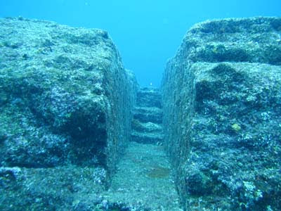
The Yonaguni Monument is an enormous underwater rock formation that covers an area of 60 by 50 meters. It was first discovered in the mid-1980s by a scuba diver looking to observe hammerhead sharks. It is situated off the south coast of Yonaguni, an island in Japan’s southwest corner, about 70 miles from Taiwan and is a popular scuba diving destination. Many people believe it is a monolith carved by man thousands of years ago. Masaaki Kimura, a marine geology and seismology professor at the University of Ryukyus, spent years studying the site and believes it was man-made, suggesting that ancient people once lived where it stands. It’s said to be evidence of the lost continent of Mu, long since submerged following a severe hurricane.

The monument was discovered in 1986 by Kihachiro Aratake, who was diving off the coast of Yonaguni Jima, searching for a new spot to view hammerhead sharks. Accidentally straying outside of the designated safety zone, he found a massive stone structure on the ocean floor at a depth of 35 meters. Despite the heavy encrustation of coral, he explored the monument, taking photographs before returning to shore.

Exploring the Enigma of Yonaguni Monument: Evidence of a Lost Civilization?

Kimura spent over 15 years studying the site, and his observations and data led him to conclude that it was man-made, suggesting that ancient people once lived where it stands. Kimura noted several specific artificial features that supported his theory. These features include marks from tools, a retaining wall, a (suggestive) road, drainage canals, gates, stairways, and two carved monuments shaped like turtles. Kimura also found the suggested remains of tools made from stone and a massive relief carved with animals. Kimura’s evidence initially led him to conclude that the city was over 10,000 years old. Later research led him to fix his estimate to be in the range of 2,000-3,000 years old.

However, skeptics generally dispute any speculation of ancient submerged cities, and the mystery of this site is no exception. Some argue that the straight lines of the formed structure could indicate nature’s natural process of erosion, as sandstones split along horizontal bedding plains that give these regular features. Others suggest that the formation was a foundation for a since-destroyed building or even a quarry for cutting stones. Some skeptics argue that the design and construction would be too complex and challenging for such an ancient people.

The Yonaguni Monument: A Geological Oddity or Evidence of Advanced Ancient Technology?

Evidence of an Ancient Underwater City in Japan?

The Yonaguni Monument remains a subject of fascination and debate among scientists, divers, and enthusiasts alike. While some believe it to be evidence of a lost civilization, others suggest it could be a natural formation or a modified natural structure. Despite years of research and study, there is no clear consensus on its origin or purpose. As such, the mystery of the Yonaguni Monument continues to capture the imagination of people around the world, drawing them to the shores of Yonaguni island to explore its underwater wonders and contemplate the enigma that lies beneath the surface of the sea.

Articles you might like:

Monday 17 April 2023

Uncovering the Secrets of Indonesia's Hidden Pyramid

The Oldest Pyramid in the World? Exploring the Mysteries of Gunung Padang

An enormous pyramid-like structure in Indonesia may represent the remains of an ancient temple that hid underground for thousands of years. Located atop Mount Padang in West Java, the structure is topped by an archaeological site that was discovered in the early 19th century and holds rows of ancient stone pillars. But the sloping “hill” underneath isn’t part of the natural, rocky landscape; it was crafted by human hands, scientists discovered.

While it may superficially resemble a pyramid, the structure differs from similar pyramids built by the Mayans. While Mayan pyramids tend to be symmetrical, this structure is elongated, with what appears to be a half-circle in the front.

Using ground-penetrating radar surveys, X-ray tomography, 2D and 3D imaging, core drilling, and excavations, researchers gradually uncovered several layers of a sizable structure. It spread over an area of around 15 hectares (150,000 square meters) and had been built up over millennia, with layers representing different periods. At the very top were pillars of basalt rocks framing step terraces, with other arrangements of rock columns “forming walls, paths, and spaces,” the scientists reported at AGU. They estimated this layer to be about 3,000 to 3,500 years old.

Underneath the surface, to a depth of about 10 feet (3 m), was a second layer of similar rock columns, thought to be 7,500 to 8,300 years old. And a third layer, extending 49 feet (15 m) below the surface, is more than 9,000 years old and could even date to 28,000 years ago, according to the researchers. Their surveys also detected multiple chambers underground.

Exploring Indonesia's Pyramid: The Search for Ancient Civilizations

Danny Hilman Natawidjaja, lead project researcher and a senior scientist with the Indonesian Institute of Sciences, thinks Gunung Padang may be the oldest pyramid still standing on Earth. He and his colleagues suspected that the exposed megalith might be more than it appeared, because some partly exposed features in the existing archaeological site didn’t quite match the standing stones. The “peculiar” shape of the hill also stood out from the landscape, he said.

Today, local people still use the exposed site at the top of the structure as a sacred destination for prayer and meditation, and this could also be how it was used thousands of years ago, Natawidjaja said. However, the purpose of the pyramid remains a mystery, as does whether there is a tomb at its heart.

Gunung Padang has been an ancient pyramid hiding underneath a mountain in Indonesia for millennia. It looks like a large hill covered in broken columns of ancient volcanic rock, a kind of prehistoric graveyard where all the tombstones have been knocked down. For many years, archeologists thought the site was an ancient megalithic site, the remains of some stone monument prehistoric peoples had cobbled together on raised ground for a purpose lost to time.

While it was the largest megalithic site in Indonesia, it wasn’t nearly as significant as those in other places, and its stones weren’t the oldest; they were dated to around 2,500 years ago. Interest in the site was limited — that is, until 2010 when Danny Hilman Natawidjaja arrived on the scene.

Hilman thought there was more to the site than anyone suspected — and he was going to prove it. Using careful excavations and remote sensing techniques like ground-penetrating radar and seismic tomography, he and his team got to work.

Archaeologists Discover Ancient Temple Hidden Beneath Indonesian Hill

The majority of the 100-meter hill is man-made, and it’s not actually a hill at all. It’s a terraced pyramid built up over millennia by the oldest civilizations the region has ever known. Natawidjaja and his team began uncovering layer after layer of the structure, each one revealing more about the incredible feat of engineering that created it.

The bottom layer, buried beneath several meters of soil and rock, is thought to be more than 28,000 years old. If that date is accurate, it would mean the pyramid was built during the last Ice Age, when the region was still a lush tropical paradise. That makes it more than twice as old as the oldest known pyramid in Egypt, and nearly as old as the last glacial maximum, the coldest and most severe period of the Ice Age.

As Natawidjaja and his team worked their way up through the layers of the pyramid, they found evidence of more recent civilizations that had built on top of the older layers. The second layer, dating to around 8,000 years ago, showed signs of being heavily modified and possibly used for religious or spiritual purposes. The third layer, built around 3,000 years ago, was even more complex, with intricate terraces, staircases, and rooms built into the pyramid itself.

The topmost layer, which is exposed to the air, was built by the Sundanese civilization around 2,500 years ago. It consists of a series of stone pillars and terraces, and is thought to have been used for religious ceremonies and possibly even as an astronomical observatory.

As the team continued their excavations, they discovered evidence of multiple chambers and tunnels beneath the surface of the pyramid. Some of these chambers are thought to be burial chambers, while others may have been used for ritual purposes. The team also found evidence of water channels and reservoirs, suggesting that the pyramid may have been designed to channel water for agricultural purposes.

Despite all this evidence, there is still much we don’t know about the pyramid at Gunung Padang. We don’t know who built it, or why, or even what it was used for. Some have suggested that it may have been a temple or a tomb, while others believe it was an ancient power plant or even a UFO landing pad.

Whatever its purpose, the pyramid at Gunung Padang is an incredible achievement of ancient engineering and a testament to the ingenuity and creativity of our distant ancestors. As Natawidjaja and his team continue to work on the site, we can only imagine what other secrets it may reveal about the forgotten history of our planet.

Wednesday 12 April 2023

Human Footprint from the Dinosaur Era: Evidence of an Advanced Civilization?

The Zapata Print: Evidence of Advanced Life on Earth Millions of Years Ago?

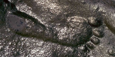
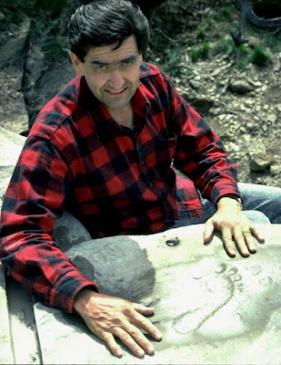
A human footprint, seemingly left behind nearly 299 million years ago, has been discovered in New Mexico. The rock, which belongs to the Permian Period (299 to 251 million years ago), contains a genuine human footprint, according to Dr. Don Patton. However, the Permian Period was a time when humans weren't supposed to exist. So, what does this finding suggest?

The enigmatic footprint has been a subject of controversy, with some experts claiming that it displays several "unnatural features" and isn't typical of genuine human prints. The line and position of the toes are somewhat unnatural, and the ball is narrower and round compared to most genuine prints. But, the print's authenticity has been confirmed by the mud up-push, a rim of raised relief around the print.

Despite the controversy, some researchers believe that this finding may be evidence of ancient civilizations on Earth. If we accept that our planet has been inhabited by countless ancient civilizations in the past and that advanced life has existed for millions of years, this finding could challenge what we know about our planet's history.

Did Humans Co-Exist with Dinosaurs? The Mystery of the Zapata Print

However, the enigmatic Permian footprint is not the only controversial find from this period. Palaeontologist Jerry MacDonald has collected a number of fossil tracks that include a few "problematica." These tracks feature creatures that appear to be walking on their hind legs, others that look almost simian, and a three-toed creature that apparently took a few steps and then disappeared, as though it took off and flew. MacDonald has several tracks with unusually large, deep, and scary-looking footprints, each with five arched toe marks, like nails, that look just like bear tracks. Mammals, including bears, evolved long after the Permian period, scientists agree, yet these tracks are clearly Permian.

The discovery of the Zapata track raises fascinating questions about the history of life on Earth. While some researchers believe that the Permian rock contains a genuine human footprint, others dispute its authenticity. Regardless of whether the footprint is real or not, it's clear that our understanding of Earth's history is incomplete, and that there may be many mysteries left to uncover. The possibility that advanced civilizations existed millions of years ago challenges conventional notions about the origins of human history, and raises new possibilities for exploration and discovery. As we continue to uncover new evidence about our planet's past, we may discover that the story of human history is far more complex and fascinating than we ever imagined. Whether or not the Zapata track is real, it serves as a reminder that there is always more to learn about the history of our planet and the life that has inhabited it over the ages.

Friday 7 April 2023

The Antikythera Mechanism: A Glimpse into the World's Oldest Computer

Discover the Antikythera Mechanism, an ancient Greek computer used to predict astronomical positions and eclipses.

The Antikythera mechanism, an ancient device that is also called the world's oldest computer due to its capability of performing astronomical calculations, has been a mystery since its discovery by sponge divers off the coast of the Greek island of Antikythera in 1901. This device, built around 2,200 years ago, was capable of performing various calculations, including tracking the motions of the sun, moon, and five of the planets, predicting astronomical events like lunar eclipses and even revealing the dates of athletic competitions such as the Olympics. The remains of the mechanism are now housed in the National Archaeological Museum in Athens.

According to a 2021 study published in the journal Scientific Reports, only 82 fragments, which consist of about one-third of the original mechanism, have survived to this day. Scholars have been trying to understand the device since its discovery, and although they have made considerable progress, many questions remain unanswered, such as who made it. Researchers are uncertain about the creator's identity, although some scholars have suggested that the Greek inventor Archimedes (287 B.C. to 212 B.C.) was the creator of the mechanism.

The inscriptions on the mechanism are written in Greek, and whoever made the device would have had to know a great deal about astronomy, metallurgy, and mechanology, as well as needing "great hand dexterity." The Functional Reconstruction of Antikythera Mechanism (Frame) project aims to reconstruct the original appearance of the mechanism and gain a better understanding of it.

Decoding the Antikythera Mechanism: The Mysterious Ancient Computer

The recovered fragments of the mechanism contained inscriptions, and over the past two decades, scientists have been able to read more of these Greek inscriptions using high-tech imaging methods such as 3D X-ray scanning. This has allowed researchers to learn more about how the mechanism worked. CT scans have revealed inscriptions that describe the motions of the sun, moon, and all five planets known in antiquity and how they were displayed as an ancient Greek cosmos. The mechanism used cycles from Babylonian astronomy, mathematics from Plato's Academy, and ancient Greek astronomical theories.

According to Alexander Jones, a professor of the history of the exact sciences in antiquity at New York University's Institute for the Study of the Ancient World, the mechanism represents "a level of technology exceeding anything else of the kind for which we have either physical remains or detailed descriptions from antiquity." In his book, "A Portable Cosmos: Revealing the Antikythera Mechanism, Scientific Wonder of the Ancient World," (Oxford University Press, 2017) Jones highlights the importance of the device, stating that it was a "mechanical computer of bronze gears" that used groundbreaking technology to make astronomical predictions.

The front of the mechanism contained dials that showed the movements of the sun, moon, lunar nodes, Mercury, Venus, Mars, Jupiter, Saturn, and the Zodiac calendar. The back of the mechanism had dials showing the Metonic cycle, the Callippic cycle, the Olympiad cycle, the Saros cycle, and the exeligmos. Between the front and back of the mechanism were numerous gears that depicted the correct timing of all the cycles.

Archimedes and the Antikythera Mechanism: Uncovering the Potential Creator of the Ancient Computer

Suppose a user of the Antikythera Mechanism wants to check eclipse predictions for a particular month some years ahead. In that case, the user winds the mechanism forwards to the right month and then sets the lunar phase indicator to match the moon's phase at the time. Then the user turns the lunar calendar dial until the phase indicator points to the correct phase. Finally, the user rotates the upper back dial to line up the correct eclipse prediction with the phase and the lunar month.

Although researchers have learned a great deal about the Antikythera mechanism, many questions remain unanswered. For example, it is still unclear who made the mechanism and where it was made. Some scholars believe that the device was created on the island of Rhodes, while others think it was made in Corinth or Alexandria.

Another question that has puzzled researchers is how the mechanism was used. While it is believed to have been an astronomical tool used to predict eclipses and the positions of the planets, the exact method of operation is not entirely clear. Some researchers think that the mechanism may have been used in conjunction with a series of dials and pointers, while others believe that it was operated using a crank.

The Antikythera mechanism is an extraordinary artefact that provides a glimpse into the sophisticated technology and scientific knowledge of the ancient Greeks. Discovered over a century ago, the mechanism continues to fascinate and challenge scholars who seek to understand its workings and purpose. Through meticulous analysis and innovative techniques, researchers have made significant progress in deciphering the mechanism's complexity and revealing its astronomical and calendrical functions. However, many mysteries remain, such as the identity of its creators and the precise context in which it was used. Despite these uncertainties, the Antikythera mechanism stands as a testament to the ingenuity and creativity of human civilization, and a reminder that our ancestors were capable of achieving remarkable feats of engineering and science. As new discoveries are made and new technologies are developed, it is likely that our understanding of the Antikythera mechanism will continue to evolve, offering new insights into the history of ancient Greece and the development of technology and science.

Articles you might like: 

Tuesday 4 April 2023

300-Million-Year-Old Wheel Discovered in Mine

Unexplained Discovery: Miner’s Photographs Reveal Fossilized Wheel Print

In 2008, a group of Ukrainian miners stumbled upon what appears to be the imprint of an ancient wheel while excavating the coal coking stratum J3 ‘Sukhodolsky’ in the town of Donetsk. At a depth of 900 meters (2952.76 feet), the workers were surprised to find the wheel-shaped imprint in the sandstone roof of the tunnel they had just excavated.

Unfortunately, the imprint could not be safely or successfully cut out due to the nature of the sandstone in which it was embedded. As a result, the artefact remains in situ down the coal mine. Fortunately, Deputy Chief V.V. Kruzhilin took photographs of the rare imprint and exchanged them with Mine Chief foreman S. Kasatkin, who brought news of the find to light.

The Rostov region surrounding Donetsk is situated upon Carboniferous rock aged between 360-300 million years ago, and the widely distributed coking coals have derived from the middle to late Carboniferous. As a result, the fossilized wheel print may be around 300 million years old.

Mysterious Fossilized Wheel Imprint Found in Donetsk Coal Mine

This would mean that an actual wheel became stuck millions of years ago and dissolved over time due to a process called diagenesis, where sediments are lithified into sedimentary rocks, as is common with fossil remains. The idea of a wheel existing millions of years ago is certainly a surprising one, and raises many questions about the evolution of human technology.

The testimony of S. Kasatkin, translated from Ukrainian, sheds some light on the discovery. According to his letter, the miners asked the mine director to invite scientists for a detailed examination of the object, but the director prohibited such talks and ordered them to accelerate work on passing through the section of lava and on fast ‘charging’ of the section with mining equipment.

The miners attempted to ‘cut-away’ the find with pick hammers, but the sandstone was so strong that they were afraid of damaging the imprint, and left it in place. At present, the mine is closed and access to the ‘object’ is impossible.

Without being able to definitively date the strata in which the fossilized wheel print was found, the photographs remain the only proof of this anomalous imprint. While it is difficult to verify the details beyond that which we have read, the photographs are certainly worth a mention. If the photographic evidence is legitimate, then one must question how a man-made wheel became embedded in such ancient strata when according to scientific orthodoxy, humans had not yet evolved.

Ancient Wheel Found in Coal Mine Leaves Scientists Puzzled

While the discovery of a fossilized wheel imprint in a Ukrainian coal mine is fascinating, it also raises intriguing questions about human history and the timeline of our development. If the imprint is indeed genuine, it suggests that an advanced civilization may have existed on Earth millions of years ago, far earlier than currently accepted by mainstream science.

Of course, the authenticity of the artefact remains unproven, and many sceptics argue that it is simply a natural formation that resembles a wheel. The lack of physical evidence and the difficulties in verifying the discovery make it difficult to draw any firm conclusions about its origin or age.

Nevertheless, the idea that an ancient civilization might have developed technology far beyond what we currently understand is a tantalizing possibility that should not be dismissed out of hand. The fossilized wheel imprint is a reminder that there is still much we do not know about our planet's past and the forces that shaped it.

Perhaps one day, with advances in technology and new discoveries, we will be able to shed more light on the mysteries of the past and unlock the secrets of lost civilizations. Until then, the fossilized wheel imprint will remain a fascinating but enigmatic artefact, open to interpretation and debate.

Read more - Lost City of the Grand Canyon: An Ancient Egyptian Connection?

Wednesday 29 March 2023

Underwater Lost Fortress Found In Lake Van, Turkey

Decades-Long Search Leads to Discovery of Iron Age Castle in Turkey's Lake Van

Archaeologists from Van Yüzüncü Yıl University and the governorship of Turkey's Bitlis Province have made a significant discovery at the bottom of Lake Van, the largest lake in Turkey. They have uncovered the remains of a 3,000-year-old castle belonging to the Iron Age Armenian civilization, also known as the Kingdom of Van, Urartu, Ararat, and Armenia.

This underwater discovery is considered a breakthrough in the field of archaeology as it provides new insights into the history and culture of the ancient Armenian civilization that thrived in the region over 3,000 years ago. The underwater excavations were led by a team of divers who spent years exploring the lake and its surroundings before finally unearthing the well-preserved walls of the castle.

Exploring the Depths of History: Underwater Excavations Reveal 3,000-Year-Old Fortification in Lake Van.

The lake itself is believed to have been formed by a volcanic eruption of Mount Nemrut near the province of Van. The current water level of the reservoir is about 150 meters higher than it was during the Iron Age, making the underwater exploration a challenging task. However, the team of experts persevered and finally uncovered the hidden fortress deep below the surface of the lake.

The castle's discovery sheds new light on the ancient Armenian civilization's military and architectural prowess, providing valuable information about their defensive strategies, engineering techniques, and construction materials. The well-preserved condition of the castle's walls indicates that the structure was built to withstand not only the elements but also potential attacks from enemies.

This is just one example of the importance of underwater archaeology, which provides new and exciting insights into the history of our planet. It is also a testament to the perseverance and dedication of the team of experts who spent years exploring the lake and finally unearthed this hidden treasure.

Uncovering the Secrets of Turkey's Largest Lake: 3,000-Year-Old Fortification Discovered

The discovery has generated significant interest among historians, archaeologists, and the general public alike, and it is hoped that further investigations will reveal even more about the ancient Armenian civilization and its contributions to the world's cultural heritage.

In conclusion, the 3,000-year-old fortification at the bottom of Turkey's largest lake is a remarkable find that sheds light on the ancient civilizations that once inhabited the region. The underwater excavations led by Van Yüzüncü Yıl University and the governorship of Turkey's eastern Bitlis Province have provided archaeologists with valuable insights into the Iron Age Armenian civilization, also known as the Kingdom of Van, Urartu, Ararat, and Armenia. The discovery of the well-preserved wall of the castle, thought to have been built by the Urartu civilization, is a testament to the advanced engineering and building skills of the ancient people who once lived in the region. This discovery is significant as it deepens our understanding of the region's history and provides new opportunities for further research and exploration.